Description This is a great trail to try when you start feeling you can ride anything. The singletrack is some of the most scenic and treacherous the Catalinas have to offer. It's not so much a trail you ride as one you survive. In the years since this page was first posted, much has changed: fires have come and gone, highway construction has made the road safer and added a new trailhead, and trail work has added hiker-friendly 'steps' to the trail in Bear Canyon. Don't let the shady coniferous forest at the trailheads fool you. The 2002 Bullock Fire took its toll on the northeast slope. The upper trail is unmaintained, exposed, and offers little shade. Though not recommended, it is a summer riding option if you get on the trail very early. Less forest cover means less retained moisture, more erosion, and very dry trail conditions. Expect plenty of surprises. (The forest service trail description is out of date but may be useful.) Rating This is one of the most challenging trails we've found in the Catalinas. You'll need lots of lung, skill, and nerve. Knee, shin, and elbow padding is highly recommended. How to get there According to the forest service, permits are not required to park at trailheads that have no facilities (toilets, picnic tables, water, or camping). Neither the lower nor upper Green Mountain trailheads have facilities. More information is available on the Coronado National Forest website. Take the Catalina Highway to the Bug Spring/Green Mountain Trailhead (mile 11.6) and park. Ride the highway up to the Upper Green Mountain Trailhead. If you pass San Pedro Vista you've gone too far. There are no restrooms at the upper trailhead. Hiking and Trail Running Hikers and runners can do out-and-backs from the lower or upper trailhead. The lower Bug Spring/Green Mountain Trailhead end of the trail gets the most use and shows it. The trail has lots of up-and-down for the first half mile, follows a drainage, then climbs for a couple of miles to trails to Guthrie Mountain and Maverick Spring. The Upper Green Mountain Trailhead has fewer hikers. The trail is rough and shows little maintenance between the saddle to Green Mountain and Maverick Spring. 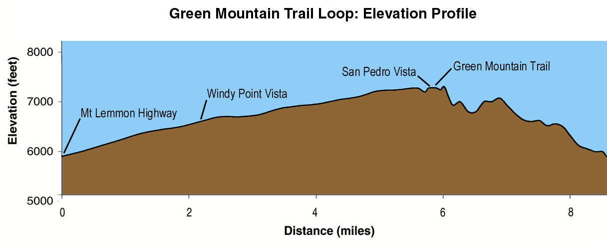 Trail Log
Notes Start early to avoid traffic on the Catalina Highway. Improvements have made the road wider but only slightly safer for bicyclists. A better road means faster drivers. Drop your seat post half and inch to an inch for the Green Mountain trail downhill. We've found that it improves bike handling and lets you sit back further on the bike in steep sections. Watch out for hikers and yield the trail, smile, and wave. In most cases they will encourage you to pass, possibly thinking that anyone crazy enough to try and ride this trail needs all the help they can get. The popular hiking section is the last few miles of trail between the Guthrie Mountain fork and the picnic area. Watch weather conditions. After a heavy rain the trail gets soft and seemingly dry roots and rocks will slide you down the hill before you know it. |
|
|
|

Copyright 1997-2024 R Scott Cherba All Rights Reserved
Updated June 2024